Contact Us
The Regency Town House
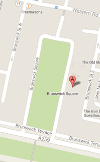
13 Brunswick Square
Brighton & Hove
East Sussex
BN3 1EH, UK
Sign up for our Newsletter
Our monthly newsletter lists our upcoming events, reviews, news from the Town House, history features and snippets, plus a local exhibition listing.
Brunswick Town Early History
Links to histories of individual houses: 18, 32, 39, 47
The land on which Brunswick Town was built was part of the Wick Estate which in turn had belonged to the Manor of Preston. It covered about 250 acres and the boundaries were roughly the coast road to the south, the Brighton/Hove parish boundary to the east, St. John’s Road to the west and Old Shoreham Road to the north. As far as we know, it has always been farmland and one meaning of the word ‘wick’, i.e., ‘farm’, would seem to confirm this.
The only geographical feature of any significance would appear to be the Chalybeate, a pool on a hill which “is covered with almost the only group of trees in the district” (Victoria County History, vol. 1). By the beginning of the 19th century this pond was becoming popular with visitors to Brighton because of its health restorative qualities. Otherwise, it was a nondescript area of land owned by the Scutt family ever since John Scutt, a Brighton brewer, bought it in 1701 from the Royalist gentry Stapeley family for £1,600. Thomas Scutt, who inherited the estate in 1783 had, from 1778 to 1790, run a brick making business, there just at a time when the building industry in Brighton was rapidly expanding.
We know that in 1783, as well as brickworks, there were barns, stables, a farmhouse, meadows, pastures, heath and furze and sheep on it, and in 1800 the first pump house was built on the Chalybeate. Sicklemore’s History of Brighton says about Wick: “This manor, the property of Rev. T. Scutt, to whom the Chalybeate also belongs, is situated near the spring upon a rising ground, enclosed and surrounded by a lawn, garden shrubbery, etc., and commanding a pleasing variety of sea and land views. The walk from Church Down to this charming situation is much frequented during the summer months, as well as those who can feel a gratification in the contemplation of the picturesque and rurally cultivated beauties of nature.”
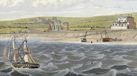
Brickworks to the west of the Western House from R. Havell 1824 A Coasting View of Brighton
This is in spite of the nearby presence of brick works. By the 1820s they had become much more intrusive. At this stage the brickworks were on the site of the future Brunswick Square and the grazing land was north of a public footpath between Brighton and Hove, about where Western Road, Hove, would be built. It was not an attractive area. Musgrave, in his ‘Life in Brighton’, says of the Brunswick area: “The site was a dreary expanse used as a brickyard, covered with heaps of ashes, rotten rubbish, and ruinous sheds and the ‘mephitic vapours’ given off by the brick-kilns gave great annoyance to the people living nearby.”
By now the owner of the estate was the Rev. Thomas Scutt, but in 1818 he sold Wick House and then 24 acres of the south west part of the Wick Estate to Thomas Read Kemp. Kemp began building on this site in May 1823, and though there is no actual documentary evidence to prove it, it certainly appeared to be a copy of the Kemp Town development. When developing his ideas for Kemp Town, he became acquainted with a younger architect, Charles Busby, who had recently returned from America full of new ideas. An architectural partnership between Busby and Amon Henry Wilds, a local builder who had done much work for Kemp, was formed. Royal interest in Brighton had encouraged many fashionable visitors to make extended visits to Brighton. They needed somewhere to live, so this was the moment to capitalise on the interest. In general terms, the pattern of building in spa towns such as Bath was followed.
But “the arrangement” in Brighton was unique in its marriage of crescent with square, and the transfer of an 18th century town planning concept to the seaside.” The background of the Downs rising up in the distance also added to the attractiveness of the setting. To judge from paintings of the area, open country lay beyond the estate. None of the early maps of the area show any evidence of building.
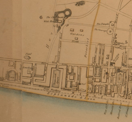
1834 Wallis map showing fields to the north of Brunswick Square
These ideas formed the background to the building of Brunswick Square, and that development very much became the brainchild of Busby. By now, Thomas Scutt was barely involved, except of course for the fact that he actually owned the freehold of the land on which it was built.
The building of Brunswick Town did not just involve the houses actually surrounding Brunswick Square, but also on the streets and houses running north to south behind them between Western Road Hove and the coast road. These were Waterloo Street, Upper and Lower Market Street and Brunswick Streets East and West, and a few other little streets and mews between them. The houses in them were built more or less at the same time, but the streets were much narrower and the houses smaller and more basic, especially East and West Brunswick Streets, which were intended for stabling and meagre living quarters on the first floor for the coachmen. The public house The Star of Brunswick in Brunswick Street West must have provided a very welcome escape.
Research by Rosemary Pugh, 2022